|
Get Weather Updates
Note: Some information in this section comes from the
GA Pilot's Guide to Weather Planning, Weather Self-Briefings,
and Weather Decision Making. (http://www.faa.gov/pilots/safety/media/ga_weather_decision_making.pdf)
Staying safe requires staying alert to weather changes. GA pilots and their aircraft
operate in (rather than above) most weather. At typical GA aircraft speeds, making
a 200-mile trip can leave a two to three hour weather information gap between the
preflight briefing and the actual flight. In-flight updates are vital. Sources of
enroute weather information include:
Visual Updates. One of the most important things you can do is to
look outside. Use your eyes to survey the weather and literally see whether the
conditions around you match the conditions that were reported or forecast. Sometimes
there are local deviations in weather conditions (isolated cells, fog, etc.) that
may not be immediately known to the FSS specialist or that may not appear on
weather-product depictions, especially if there is no weather-reporting capability
at your departure point. Even if you looked at radar during your preflight briefing
process, remember that NEXRAD data is at least 8 minutes old by the time you see it
on a display, and older still by the time you are ready to depart. Weather can
change very rapidly.
ATIS/ASOS/AWOS. One of the easiest ways to monitor conditions en
route is to listen periodically to ATIS and ASOS/AWOS broadcasts along your route.
These broadcasts can help you update and validate preflight weather information about
conditions along your route of flight. As you approach your destination, be sure to
write down information from the current ATIS, ASOS, or AWOS broadcast.
Enroute Flight Advisory Service (EFAS, or Flight Watch). Available
on 122.0 in the continental United States from 5,000 AGL to 17,500 MSL (124.67 at
higher altitudes), EFAS, addressed as Flight Watch, is a service specifically
designed to provide en route aircraft with timely and meaningful weather
advisories pertinent to the type of flight intended, route of flight, and altitude.
If you are in contact with ATC, request permission to leave the frequency to contact
EFAS. Provide your aircraft identification and the name of the VOR nearest to your
position.
Air Traffic Control (ATC). Pay attention to the chatter on the ATC
frequency. Are other GA aircraft along your route requesting diversions? You can also
request information on the present location of weather, which the controller will
try to provide if workload permits. Note: Please see the separate Learning Center
Library documents on new ATC procedures for describing weather radar echo data to pilots.
Datalink and Weather Avoidance Equipment. Radar and lightning
detectors have been available in some GA aircraft for many years. These devices
can contribute significantly to weather awareness in the cockpit. An increasing
number of GA aircraft are now being equipped with weather datalink equipment,
which uses satellites to transmit weather data such as METARs, TAFs, and NEXRAD
radar to the cockpit, where it is often shown as an overlay on the multifunction
display (MFD). Handheld devices with weather datalink capability are also a
popular source of en route weather information. Bear in mind, though, that one
of the most important, and critical, things to know about datalink is that
regardless of the transmission method, it does not provide "real-time"
information and must not be used for "tactical" weather flying.
Brief the Approach
After obtaining the most recent weather from ATIS, ASOS, or AWOS, it is time to review
the appropriate approach chart. If you have another qualified pilot on board, ask him
or her to brief the approach. If you are operating as a single pilot, brief yourself.
You may want to use the following format:
 | |
| | |
| | |
| | | | | | | |
| | |
| | | | Type of Approach | "This will be a straight-in VOR approach to Runway 23 at Bedford
Airport." | | | | |
| | |
| | | | Frequencies | "VOR frequency is 115.3 MHz; tower is 119.0." | | | | |
| | |
| | | | Headings | "Final approach course is 228 degrees." | | | | |
| | |
| | | | Altitudes | "The MDA for this approach is 680'." | | | | |
| | |
| | | | Rate of Descent | "The required rate of descent is 500 fpm at 120 knots indicated." | | | | |
| | |
| | | | Timing | "Time from FAF to missed approach point is 2 minutes." | | | | |
| | |
| | | | Elevation | "Field elevation is 133; touchdown zone elevation is 333." | | | | |
| | |
| | | | Runway length | "Runway length is 6,500." | | | | |
| | |
| | | | Notes | "ADF required; use Boston altimeter setting if local setting not received."
| | | | |
| | |
| | | | Missed Approach Procedure | "MAP is climbing right turn to 2,000, direct BE LOM and hold." | | | | |
| | |
| | | | | |
| | |
| | |
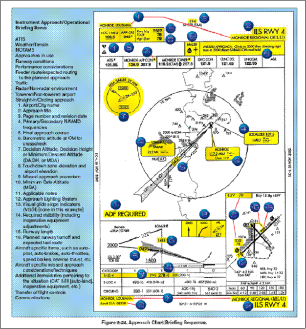
For another approach brief option, see Figure 5-24, FAA-H-8261-1
Instrument Procedures Manual.
To the extent that your equipment permits, set up radios and navigational aids for the
approach (e.g., put approach frequencies into the "standby" position on your
comm and nav radios). It is also a good idea to set up radios for the missed approach
procedure before starting the actual approach.
|


