1. General. The basic requirement for operating VFR within this airspace is to be in two-way radio communications with ATC – generally that’s Eglin Approach. If you are on VFR Flight Following, you will generally be told when to contact Eglin Approach. If you have not been talking with another Approach Control facility (Cairns to the north, Tyndall to the east and Pensacola to the west), then you need to establish contact with Eglin Approach well prior to entering their airspace. Also, try to check the Destin ATIS/ASOS (133.92) before getting into Eglin’s busy airspace. Destin’s Delta airspace is generally active between the hours of 6 AM an 10 PM local time and the ATIS will confirm if the Tower is open or not. Also, if you have a number two radio available, go ahead and tune and monitor Destin Tower on 118.45.
2. From the North. When arriving from this direction, you will generally want to fly south through the VFR corridor. Thus, call Eglin Approach on 124.05 (as shown on the Sectional, see Figures 2 and 3) approximately 10 to 15 miles north of the boundary and advise them of your intentions; remember to listen for a clear frequency before keying your mic.
Sample transmission:
Pilot: Eglin Approach, Cessna 12345, 10 miles northeast of Crestview airport, request clearance south through the corridor to Destin.
The standard VFR routing south through the North-South Corridor is first direct to a Visual Check Point shown on the Sectional as “FIELD 2” and then to a Visual Check Point called “WHITE POINT”, also shown on the Sectional at the northern end of the very prominent Mid-Bay Bridge. Eglin will generally ask if you are familiar with this routing and if you are, it will be issued. If you are not, you can expect vectors that may be more circuitous.
Sample transmission:
Eglin: Cessna 12345, squawk 46XX.
Cessna 12345, radar contact position reported. Are you familiar with Field 2 – White Point?
Pilot: Eglin Approach, Cessna 12345, we are familiar with Field 2 – White Point.
Eglin: Cessna 12345, you are cleared south through the corridor via Field 2 – White Point.
OR
Eglin: Cessna 12345, fly heading XXX.
If you are cleared Field 2 – White Point, you should be looking for a triangular airport layout to the southeast of Duke Field – an active Air Force base, that also has a somewhat triangular shape but having more of a cleared area. Field 2 is shown in Figure 6.

Figure 6. The Visual Check Point, Field 2, from the north.
On the Sectional, you will see that the North-South Corridor ends just north of the Destin airport. Generally, prior to reaching White Point, Eglin Approach will change you to the sector controlling the East-West Corridor – generally 132.1. That Controller will generally make sure that you don’t have Eglin AFB confused with Destin. This exchange often goes something like this.
Sample transmission:
Eglin: Cessna 12345, Contact Eglin on 132.1
Pilot: Eglin Approach, Cessna 12345 going to 132.1
Pilot: Eglin Approach (on 132.1), Cessna 12345 at (say your altitude).
Eglin: Cessna 12345, radar contact.
Subsequently:
Eglin: Cessna 12345, Eglin AFB is 2 O’clock at 4 miles and Destin is 1 O’clock at 9 miles; advise when you have both in sight.
Eglin AFB is shown in Figure 7, and White Point is shown in Figure 8.

Figure 7. Eglin AFB as seen from the east while approaching Visual Check Point, White Point.

Figure 8. White Point and the Mid-Bay Bridge as seen from the north.
Then advise Eglin Approach:
Pilot: Eglin Approach, Cessna 12345 has Eglin and Destin in sight.
Eglin: Cessna 12345, contact Destin Tower on 118.45.
This handoff will be just like any other you have experienced from an Approach Control facility to a Tower.
At this point, change to Destin Tower and report:
Pilot: Destin Tower, Cessna 12345 is (your location), with Information (state ATIS Letter).
Destin Tower will reply with something like:
Destin Tower: Cessna 12345, report (a particular location, e.g., “The Flag”, see Figure 9).
You should plan your descent so you will be down to 1,000 feet by the time you get to White Point; proceed as directed by Destin Tower.
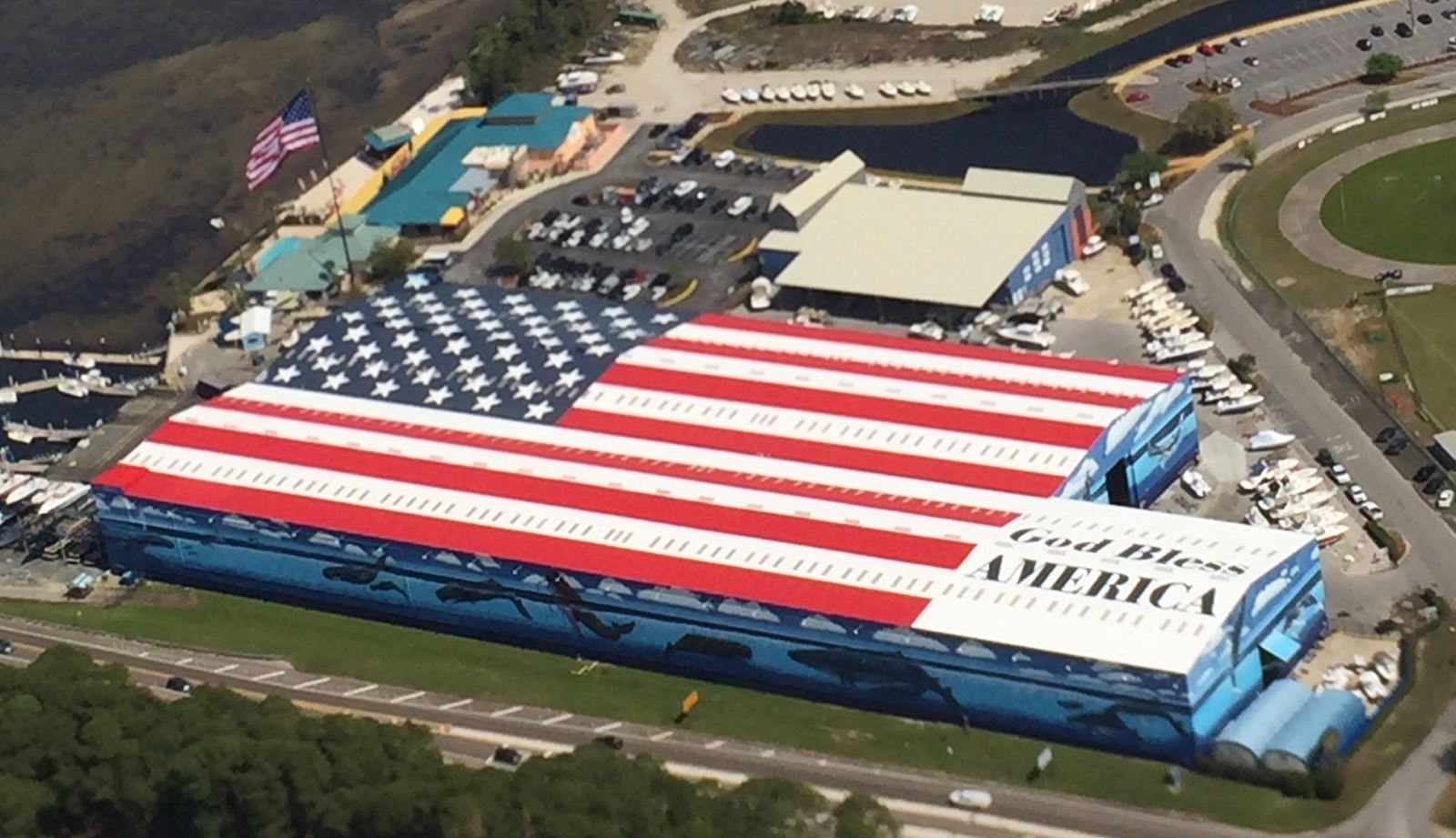
Figure 9. The US Flag at the southern end of the Mid-Bay Bridge is a prominent VFR checkpoint.
3. From the East. As from the north, prior to entering the busy Eglin airspace, listen to the Destin ATIS/ASOS on 133.925. The airspace to the east of the Destin/Eglin AFB Part 93 airspace is controlled most of the time by Tyndall Approach. When Tyndall is closed, the airspace reverts to Jacksonville Center, but the same frequencies are used. When arriving from this direction, you would probably already be getting VFR Flight Following from Tyndall Approach because of the many MOAs in that area and the high level of military activity along the coast. If this is the case, Tyndall will tell you when to contact Eglin Approach. If you are not working with Tyndall, you will want to call Eglin Approach on 132.1 (as shown on the Sectional) approximately 10 to 15 miles east of Phillips Inlet, a Visual Check Point on the Sectional, and advise them of your intentions (see Figure 10). And, remember to listen for a clear frequency before keying your mic.

Figure 10. Phillips Inlet as seen looking west.
Sample transmission:
Pilot: Eglin Approach, Cessna 12345, 10 miles east of Phillips Inlet, request advisories west through the corridor to Destin.
Eglin: Cessna 12345, Squawk 46XX. [And subsequently] Cessna 12345, radar contact position reported. Cleared as requested, report Destin in sight.

Figure 11. The East Training Area has very high density local area training activity.
Also, be aware that as you proceed VFR from Phillips Inlet to Destin you will pass through the “East Training Area”. This is one of the areas in which the local flight schools do much of their air work. The East Training Area is not charted but its location is shown in Figure 11.
As you get within about 10 miles of Destin, look for the Mid-Bay Bridge (see “Approaching from the North” above) to assist you in picking out the Destin airport. Remember, the Destin airport is located on the south side of the Bay and Eglin AFB – the BIG airport – is on the north side of the Bay. When you definitely have Destin in sight, advise Eglin Approach.
Sample transmission:
Pilot: Eglin Approach, Cessna 12345 has Destin in sight.
Eglin: Cessna 12345, Eglin Approach, change to Destin Tower, 118.45.
At this point, change to Destin Tower and report:
Pilot: Destin Tower, Cessna 12345 is 5 miles east with Information (ATIS Letter).
Destin Tower will reply with something like:
Destin Tower: Cessna 12345, report (a particular location, e.g., “The Flag”, see Figure 9).
You should plan your descent so you will be down to 1,000 feet by the time you get to the Mid-Bay Bridge and The Flag; proceed as directed by Destin Tower.
4. From the West. As from the north, prior to entering the busy Eglin airspace, listen to the Destin ATIS/ASOS on 133.925. From this direction, it would be impractical, though not impossible, to enter the Destin/Eglin AFB Part 93 airspace without going through the Pensacola Class C airspace. An added benefit of being in contact with Pensacola Approach is that they will provide you with a handoff to Eglin Approach at the appropriate time. Generally that will be just to the west of the Navarre Bridge Visual Check Point. The Navarre Bridge is shown in Figure 12.

Figure 12. The Navarre Bridge as seen looking east toward Eglin airspace.
Sample transmission:
Pensacola: Cessna 12345, Pensacola Approach, you are leaving my airspace to the east. Contact Eglin Approach on 132.1.
Or:
Pensacola: Cessna 12345, Pensacola Approach, you are leaving my airspace to the east. Radar service terminated, squawk and maintain VFR. Suggest you contact Eglin Approach on 132.1.
In either case, you would acknowledge Pensacola’s instructions and call Eglin. And, remember to listen for a clear frequency before keying your mic.
Sample transmission:
Pilot: Eglin Approach, Cessna 12345, at Navarre Bridge, VFR to Destin.
Eglin: Cessna 12345, Eglin Approach, squawk 46XX.
Pilot: Eglin Approach, Cessna 12345, wilco.
Eglin: Cessna 12345, Eglin Approach, radar contact.
If your selected VFR altitude is below the Hurlburt Field Class D ceiling of 2500 feet, Eglin will have you contact Hurlburt Tower on 126.5 and report when you are 6 to 8 miles west of the field and again when you clear the Class D airspace to the east. Generally it is simpler, weather permitting, to remain at 2500 feet or above so you can stay with Eglin Approach. However, if you are going to enter Hurlburt’s Class D, Eglin Approach will ask you to call Hurlburt Tower.
Sample transmission:
Pilot: Hurlburt Tower, Cessna 12345, 7 miles west at 1500 feet, request to transit your Delta Airspace enroute to Destin.
Hurlburt: Cessna 12345, Hurlburt Tower, altimeter 30.00, wind 180 at 5, Runway 18 is active. Cleared into the Delta Airspace, report 5 miles east.
Pilot: Hurlburt Tower, Cessna 12345, wilco.
There is a VFR Checkpoint “Brooks Bridge” on the Sectional and shown in Figure 13, that marks the eastern boundary of Hurlburt’s Class Delta that you want to use with Hurlburt Tower, Eglin Approach and Destin Tower.

Figure 13. Brooks Bridge is a VFR checkpoint marking the eastern boundary of Hurlburt’s Class Delta.
Before you get to Brooks Bridge, you should be able to see Destin airport on the south side of the Bay. If you have remained at or above 2500 feet and are with Eglin Approach, advise them of Destin in sight as soon as you have it positively identified. If you transited Hurlburt's airspace, you will need to quickly get back with Eglin after Brooks Bridge and advise them when you definitely have Destin in sight.
Sample transmission:
Pilot: Eglin Approach, Cessna 12345 has Destin in sight.
Eglin: Cessna 12345, Eglin Approach, contact Destin Tower on 118.45.
At this point, change to Destin Tower and report:
Pilot: Destin Tower, Cessna 12345 is 5 miles west with Information (ATIS Letter).
Destin Tower will reply with something like:
Destin Tower: Cessna 12345, Report (a particular prominent location).
You should plan your descent so you will be down to 1,000 feet by the time you are within 4 miles of the airport; proceed as directed by Destin Tower.
IF ARRIVING WHEN DESTIN TOWER IS CLOSED
If Destin Tower is closed, Destin airport operations revert to those of a standard non-towered airport. Note that the CTAF frequency is the same as the Tower: 118.45 and that runway and taxiway lights will be by Pilot Controlled Lighting (PCL) with 3 to 5 clicks on the CTAF frequency.
From the North. Everything remains the same as above until approaching White Point. Again, on the Sectional, you will see that the North-South Corridor ends just north of the Destin airport. Generally, prior to reaching White Point, Eglin Approach will change you to the sector controlling the East-West Corridor – generally 132.1. That Controller will generally make sure that you don’t have Eglin AFB confused with Destin. This exchange often goes something like this.
Sample transmission:
Eglin: Cessna 12345, Contact Eglin on 132.1
Pilot: Eglin Approach, Cessna 12345 going to 132.1
Pilot: Eglin Approach (on 132.1), Cessna 12345 at (say your altitude).
Eglin: Cessna 12345, radar contact.
Subsequently:
Eglin: Cessna 12345, Eglin AFB is 2 O’clock at 4 miles and Destin is 1 O’clock at 9 miles; advise when you have both in sight.
Then advise Eglin Approach:
Pilot: Eglin Approach, Cessna 12345 has Eglin and Destin in sight.
Eglin: Cessna 12345, change to Destin Advisory, 118.45, is approved.
Occasionally, when Destin Tower is closed, Eglin Approach will ask you to remain clear of Eglin’s Class Delta airspace. This is due to the fact that their display shows Eglin’s Class D as a 5 mile circle around Eglin AFB. Their intent is that you remain clear of Eglin AFB’s traffic pattern and this can be done by remaining within one mile of the north end of the Destin airport.
At this point, change to Destin Advisory and report:
Pilot: Destin Traffic, Cessna 12345 is 5 miles northeast, request Traffic Advisory.
Destin Unicom may sometimes reply with something like:
Destin: Cessna 12345, Destin is using Runway 14 (or 32), Left-Hand Pattern, with traffic.
Again, you should plan your descent so you will be down to 1,000 feet by the time you get to White Point. If you then go slightly east of the southern end of the Mid-Bay Bridge, overfly the VFR Checkpoint “US FLAG”, and turn toward the Destin airport you will be in a good position to enter either the 45 to the Left Downwind Leg for Runway 14 or Left Crosswind for Runway 32 about 3 miles east of the airport. Please see Figure 14.

Figure 14. Entries to Runways 14 and 32 shown with standard left traffic pattern.
Remember to try to stay at 1,000 feet and to keep your Base Leg to 14 or Crosswind to 32 as close as feasible to the Destin airport due to the close proximity of Eglin AFB to the north.
From the East and West and Tower is closed. When arriving from the east or west, the procedures are the same as those described above in Sections 3 and 4 until getting Destin in sight. At that point, advise Eglin Approach and they will change you to Destin Advisory, 118.45. Again, plan your descent to be at 1,000 feet by the time you are about 5 miles out. Then enter the Destin VFR pattern; locals recommend using the pattern entries shown in Figure 13. Make all normal traffic pattern radio calls for a non-towered airport.
Destin Tower is open from 6:00 AM to 10:00 PM Local, seven days a week. When it is closed, Destin’s Tower frequency becomes the CTAF and Eglin Clearance takes over for Destin Clearance on 121.6. Thus, you will use the same frequencies to get your clearance and departure instructions (121.6) and make your normal non-Towered airport position calls (118.45).
The main thing to remember about departing Destin VFR is that Eglin AFB is only 4.9 miles to the north so Destin Tower will be giving you takeoff instructions that will keep you well clear of Eglin traffic. As with many airports, Destin Ground and Destin Clearance are on the same frequency. Thus, before starting to taxi, contact Destin Ground on 121.6 with your request.
Sample transmission:
Pilot: Destin Ground, Cessna 12345, has ATIS Information (ATIS Letter), is going VFR to [say what your destination airport is].
Generally, Destin is very good about putting a flight plan in the National Airspace System for you. Often this will result in “IFR-like” hand-offs from one ATC facility to the next. However, this will take them a minute to accomplish after they have confirmed with you the 3-letter identifier and planned altitude. Eventually, they will come back with something like the following for a departure from Runway 14:
Destin Ground: Cessna 12345, your departure instructions are to maintain Runway Heading at or below 1600 feet until in contact with ATC on frequency 132.1, squawk XXYY; advise when ready to taxi.
Pilot: Destin Ground, Cessna 12345, on departure we’ll maintain Runway Heading and 1600 feet until in contact with 132.1. Subsequently: Destin Ground, Cessna 12345, ready to taxi.
Destin Ground: Cessna 12345, Runway 14 taxi via ALPHA to A-1, hold short of Runway 14 (or, Runway 32 taxi via ALPHA to A-6, hold short of Runway 32).
Pilot: Destin Ground, Cessna 12345, taxi via ALPHA to A-1, hold short of 14 (0r, . . . to A-6, hold short of Runway 32).
When #1 at Runway 14, call Destin Tower on 118.45.
Pilot: Destin Tower, Cessna 12345, we’re number one for Runway 14, ready for takeoff.
Destin Tower, when traffic permits: Cessna 12345, cleared for takeoff, fly runway heading.
Pilot: Destin Tower, Cessna 12345, cleared for takeoff.
Destin Tower, subsequently: Cessna 12345, contact Eglin Departure 132.1.
Pilot: Destin Tower, Cessna 12345, changing to Departure.
And for Runway 32, the instructions are different due to the close proximity of Eglin AFB to the north. After you have contacted Destin Ground and provided your information, Ground will say something like
Destin Ground: Cessna 12345, on departure, turn left heading 180 within one half (1/2) mile of the end of the runway, climb and maintain 1600 feet, until in contact with ATC on frequency 132.1, squawk XXYY.
The subsequent dialog would be similar to that for Runway 14.
After departure and you have contacted Eglin Departure, they will do all they can to expedite your exit from the Part 93 airspace enroute to your destination. If you want to go north through the North – South Corridor, ask Eglin for clearance through the corridor and you may get expedited treatment if you tell Eglin you want to go via White Point – Field 2. You can also expect a frequency change shortly after getting turned north and have transitioned from the East-West to North-South corridor. Also, as you proceed north from WHITE POINT towards FLIELD 2, you will see a large arrow cut in the trees that is pointed at FIELD 2. A clear field of view that is needed for one of Eglin’s ranges also serves as a visual aid with respect to FIELD 2 when heading north.
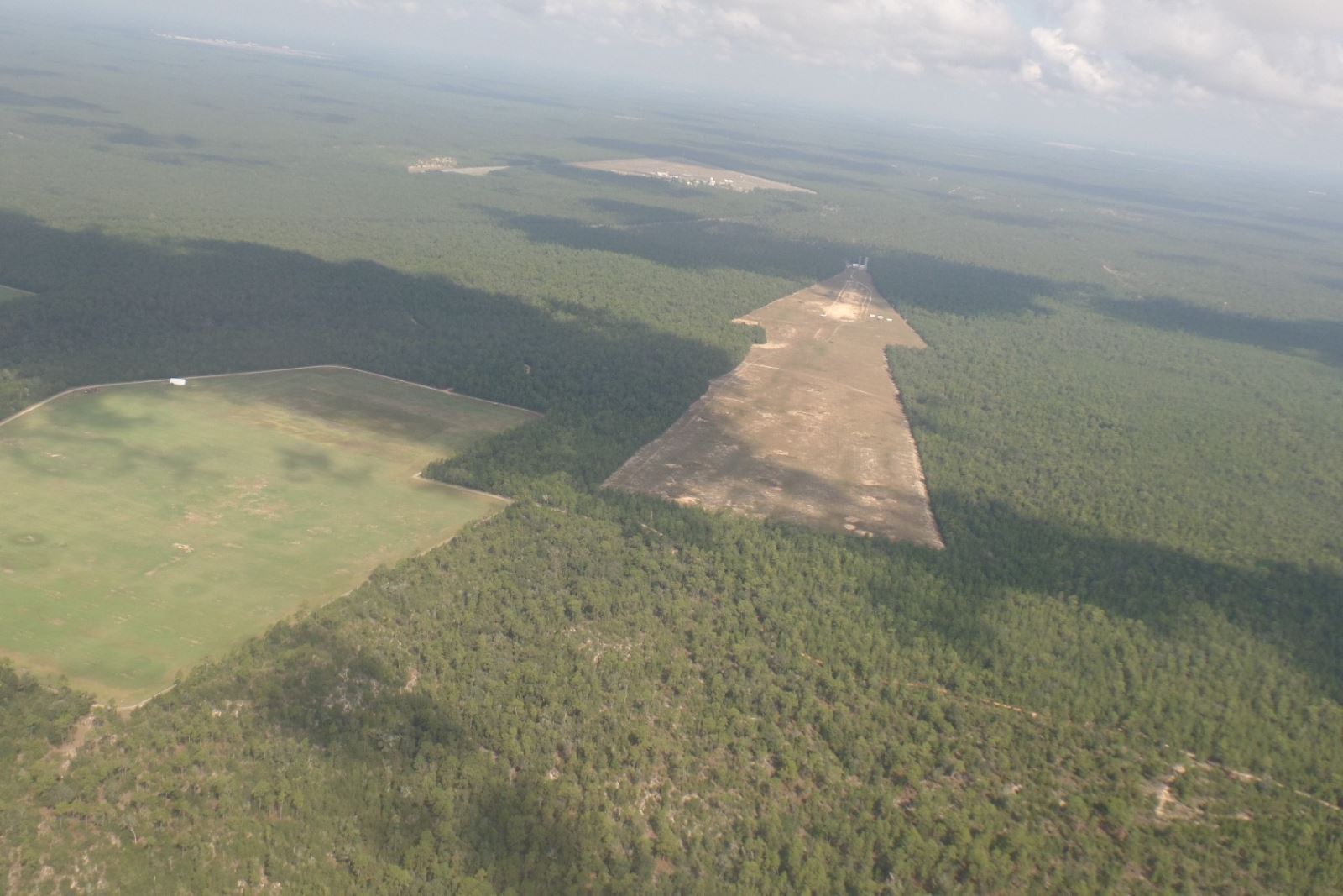
Figure 15. A large arrow that has been cut into the trees for other purposes points to FIELD 2.
If you are departing the area to the east or west, the same Visual Check Points that you used inbound will be helpful outbound.


