FAR Part 93 Airspace is very rare; in addition to Destin/Eglin AFB (officially the “Special Air Traffic Rule, FAR Part 93 Valparaiso Terminal Area”), there is only one other listed in the Airport/Facilities Directory: “Reservations for high density airports - Kennedy, LaGuardia, and Washington Reagan National”. So you can see that this classification of airspace deals with areas having particular and unique needs.
In the case of the Destin/Eglin AFB Part 93 airspace, the challenge is to safely weave civilian commercial and general aviation flying into the on-going and intense military mission of Eglin AFB.
This airspace is located in the Florida Panhandle roughly south of US Highway 90 and between Pensacola, Florida and Panama City, Florida. It is shown on both the New Orleans Sectional and IFR Enroute charts, but its complexity and required operational procedures challenge the cartographer’s best efforts to get all pertinent information into the pilot’s hands.
The Part 93 Airspace is easiest to see as the white area on the New Orleans Sectional Chart (See Figure 2). The North-South Corridor is depicted by solid blue double-headed arrows and the East-West Corridor is depicted by open double-headed arrows (See Figure 3). The North-South Part 93 Corridor is bounded on the west by Restricted Areas R-2915A, B, and C, and on the east by R-2914A and B, R-2919A and B, and R-2918. To the south of the East-West Corridor are Warning Areas and to literally cap it all off, the Eglin E MOA is within the Eglin Restricted Areas and the Part 93 airspace.
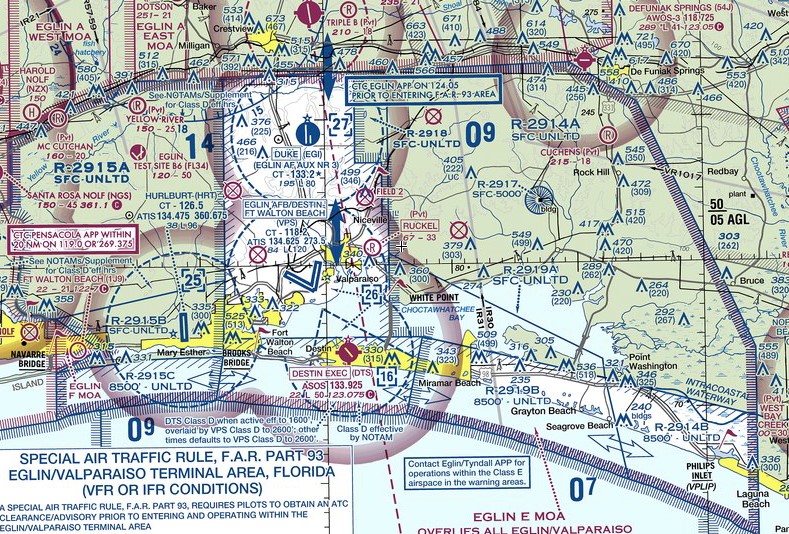
Figure 2. The Destin/Eglin AFB Part 93 airspace challenges the cartographer's capabilities.
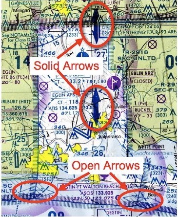
Figure 3. Open and Solid Arrows depict the Part 93 Corridors.
The Enroute chart is equally daunting for chart maker and pilot alike (See Figure 4).
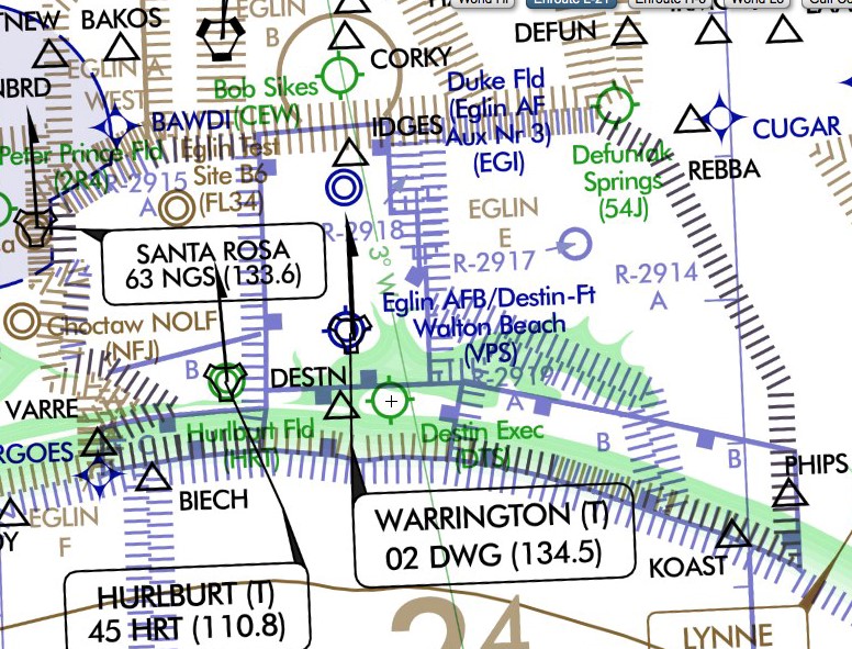
Figure 4. The IFR Enroute chart is crowded with information.
Related Media for this Section
The easiest way to remember the operating requirements here is think of the North-South Corridor with its solid blue arrows as similar to Class B Airspace in that you need a clearance to enter. You need to establish two-way radio communications with ATC (usually Eglin Approach) and get a clearance and, if so equipped, a discrete transponder code prior to entering. The East-West Corridor with its open arrows is similar to Class C Airspace in that you need to establish two-way radio communications with ATC (usually Eglin Approach) and have, if so equipped, a discrete transponder code prior to entering.
Destin’ surface Class Delta airspace is nestled within and under Eglin AFB’s Class Delta (Figure 5). The shape of this airspace is dictated by the operational requirements of Eglin AFB and the whole of the Part 93 airspace. The top of Eglin’s Delta is the standard 2500 AGL or 2600 MSL, rounded off to the next higher 100 feet. Among other missions, the aircraft based at Eglin are involved in training and testing with high speed fighter aircraft. It is not unusual for these aircraft to need to fly over DTS above 1600 MSL while in the Eglin traffic pattern. Thus, the ceiling of the Destin Delta is 1600 MSL Also, Destin’s Delta is bounded on the west and north by the approachand departure corridors of Eglin’s runways. Think about very fast aircraft flown by young invincible aviators with ejection seats and you really don’t want to get in their way!
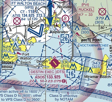
Figure 5. Destin’s Class Delta is nestled within Eglin AFB’s Class Delta.
Related Media for this Section
There are several items that the arriving pilot would want to be aware of regardless of whether he is VFR or IFR
Getting an Early Heads Up. It is a good practice to check the Destin ATIS/ASOS (133.92) before getting into Eglin’s busy airspace. You can generally pick up Destin’s ATIS/ASOS 50 or more miles from the airport, especially if you defeat squelch.
Eglin Approach Typically Works Multiple Frequencies. The Eglin Controllers typically work at least two frequencies for each sector. One frequency will be the VHF we are familiar with and the other will be the UHF military aircraft typically use. Thus, even though the VHF frequency sounds clear, you can often tell by what the Controller last said whether or not he is expecting a reply from someone else. If it sounds like he is waiting for a reply from an unheard aircraft, wait a few seconds for that exchange to be completed on the other frequency before keying your mic.
Banner Tows. Another interesting potential conflict when you enter the Destin area is the large number of banner tow airplanes that are working along the beach much of the year. Banner tow pilots are very good about making radio calls announcing their position on the appropriate frequency when they are near Destin and elsewhere along the beach. When they are eastbound along the beach they will be at 500 feet and below and when they are westbound they will be at 1,000 feet, traffic pattern altitude, and will generally pass over the southern end of the runway. They are slow moving and the banner is easy to see if you are looking for it so they are quite easy to avoid. They re most frequent from Spring Break through Labor Day, but may be flying on any nice weekend.
Sightseeing Helicopters. One or more sightseeing helicopters will often be operating along the Gulf beach at or below 500 feet. While the helicopters are in the Destin Delta airspace, they should be on the Tower frequency and the Tower will deconflict your flight paths.
Parasails. Parasails towed by boats are very common along the Destin and Ft. Walton beaches. They should remain below 200 feet and outside the Destin surface Delta airspace. Please advise the Tower if you see one that appears to be a hazard to flight.


